29 Years of Excellence
Government Licence: 396

Rock Climbing in Kanday Valley

Rock Climbing in Pakistan
previous arrow
next arrow
Rock Climbing in Kanday (Amin Brakk) 5,850-M)
 

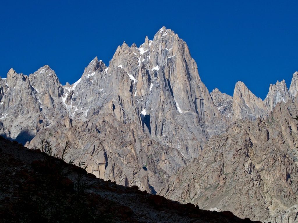
Amin Brakk is situated in the Nangma Valley of Karakoram. Amin Brakk’s height is 5,850m which is one of the wall hung in the surroundings it is an impressive wall located in a remote valley of the Karakoram. Its technical snag makes appealing to adventure lovers. Amin Brakk was first attempted in May 1996 and again in 1997 by Basque climbers Jon Lazkano and Adolfo Mdinabeitia. Who had to turn back only 300m from the summit due to bad weather. Finally, Amin Brakk received its successful first ascent by Spanish climber Silvia Vidal, Pep Masip and Miguel Puigdomenech in August, 1999.

Detailed Itinerary Kanday- Amin Brakk Expedition
 

Welcome at Islamabad airport and transfer to hotel. Afternoon proceed for city tour of Islamabad and Rawalpindi, which includes famous Faisal Mosque, Shakar Parian, Pakistan monument, Damen Koh, Lok Versa, Museum, Rawalpindi old bazaar, Raja Bazaar.

Altitude: 540m.
Accommodation: Hotel
Meals: Breakfast, Lunch, Dinner

Drive to Naran 6-7 hours 239 km, after lunch continue drive to Chilas 3-4 hours 113.3 km via Babusar Pass 4,173 m.
Babusar Pass is a high mountain pass at an elevation of 4,173 m (13,691 ft) above the sea level. The pass is the highest point in the Kaghan Valley, Pakistan. The pass connects the Kaghan Valley via the Thak Nala with Chilas on the Karakorum Highway. It’s one of the famous hair pinned roads in the world.

Altitude: 1,265m.
Accommodation: Hotel
Meals: Breakfast, Lunch, Dinner

Drive to Skardu along with Indus River 8-9 hours, 290 km. En-route stop at junction point of three great mountain ranges meet, the Karakorum, Himalaya and Hindukush and stop at Thalichi for photography from Nanga Parbat 8,126m.

Altitude: 2,228m
Accommodation: Hotel
Meals: Breakfast, Lunch, Dinner

Drive to Kanday valley 4 hours. Kanday is last village and starting point of our trek. The jeep road crosses the Shyok River and passes the villages of Khaplu and Macholo.

Altitude: 2,900- M
Accommodation: Camping
Meals: Breakfast, Lunch, Dinner

Trek from Kanday village to Mingulo Broq along with Nangma River. camp at 3400-M

Accommodation: Camping
Meals: Breakfast, Lunch, Dinner

Trek from Mingulo to Amin Brakk base camp. Altitude 3450-M                           

Accommodation: Camping
Meals: Breakfast, Lunch, Dinner

19 days in base camp for climbing.

Accommodation: Camping
Meals: Breakfast, Lunch, Dinner

Trek down from Base Camp to Khaney village 5-6 hours

Altitude: 2,800m
Accommodation: Camping:
Meals: Breakfast, Lunch, Dinner

Drive from Khaney to Skardu 4-5 hours.

Altitude: 2,228m
Accommodation: Hotel
Meals: Breakfast, Lunch, Dinner

We fly back to Islamabad. Afternoon is free for exploring. 
Note: If our flight is cancelled due to bad weather, we will start the drive to Islamabad travelling for 9 hours along with Indus River to reach Chilas.

Altitude: 540m.
Accommodation: Hotel
Meals: Breakfast, Lunch, Dinner

Enjoy a free day in Islamabad for exploring, sightseeing and shopping. Note: If our flight on day 18 cancelled we will spend 11-12 hours driving from Chilas to Islamabad via Babusar Pass 4173m

Altitude: 540m.
Accommodation: Hotel
Meals: Breakfast, Lunch, Dinner

Transfer to Islamabad airport for return flight.

Rock Climbing in Khaney Valley

Rock Climbing in Pakistan
previous arrow
next arrow
Rock Climbing in Khaney Valley
 

The Khaney Valley is located in North-East Pakistan, in the Baltistan-Karakorum region (Tagas Group). Perpendicular to the Hushe Valley (which gives access to Masherbrum or K1) and parallel, towards South, to the more popular Nangma Valley, the Khaney valley spreads towards East. Still further North of Nangma Valley, the small Khridas Valley and the much more popular Charakusa Valley (thanks to K6 e K7) are located. The Halde Valley is positioned south to the Khaney Valley, while a mountain ridge divides the Khaney Valley from the Tagas Valley. The Khaney village, set at 2800 m (roughly 9200 feet), is the last place reachable by Jeep.

Detailed Itinerary Khaney Expedition
 

Welcome at Islamabad airport and transfer to hotel. Afternoon proceed for city tour of Islamabad and Rawalpindi, which includes famous Faisal Mosque, Shakar Parian, Pakistan monument, Damen Koh, Lok Versa, Museum, Rawalpindi old bazaar, Raja Bazaar.

Altitude: 540m.
Accommodation: Hotel
Meals: Breakfast, Lunch, Dinner

Drive to Naran 6-7 hours 239 km, after lunch continue drive to Chilas 3-4 hours 113.3 km via Babusar Pass 4,173 m.
Babusar Pass is a high mountain pass at an elevation of 4,173 m (13,691 ft) above the sea level. The pass is the highest point in the Kaghan Valley, Pakistan. The pass connects the Kaghan Valley via the Thak Nala with Chilas on the Karakorum Highway. It’s one of the famous hair pinned roads in the world.

Altitude: 1,265m.
Accommodation: Hotel
Meals: Breakfast, Lunch, Dinner

Drive to Skardu along with Indus River 8-9 hours, 290 km. En-route stop at junction point of three great mountain ranges meet, the Karakorum, Himalaya and Hindukush and stop at Thalichi for photography from Nanga Parbat 8,126m.

Altitude: 2,228m
Accommodation: Hotel
Meals: Breakfast, Lunch, Dinner

Drive to Khaney valley 4 hours. Khaney is last village and starting point of our trek. The jeep road crosses the Shyok River and passes the villages of Khaplu and Macholo.

Altitude: 2,800m
Accommodation: Camping
Meals: Breakfast, Lunch, Dinner

Two days trekking from Khaney village to Base camp.

Accommodation: Camping
Meals: Breakfast, Lunch, Dinner

21 days in base camp for climbing.

Accommodation: Camping
Meals: Breakfast, Lunch, Dinner

Trek down from Base Camp to Khaney village 5-6 hours

Altitude: 2,800m
Accommodation: Camping:
Meals: Breakfast, Lunch, Dinner

Drive from Khaney to Skardu 4-5 hours.

Altitude: 2,228m
Accommodation: Hotel
Meals: Breakfast, Lunch, Dinner

We fly back to Islamabad. Afternoon is free for exploring. 
Note: If our flight is cancelled due to bad weather, we will start the drive to Islamabad travelling for 9 hours along with Indus River to reach Chilas.

Altitude: 540m.
Accommodation: Hotel
Meals: Breakfast, Lunch, Dinner

Enjoy a free day in Islamabad for exploring, sightseeing and shopping. Note: If our flight on day 18 cancelled we will spend 11-12 hours driving from Chilas to Islamabad via Babusar Pass 4173m

Altitude: 540m.
Accommodation: Hotel
Meals: Breakfast, Lunch, Dinner

Transfer to Islamabad airport for return flight.

Rock Climbing on Baltar Glacier: Darwo Chhok- Kako Peak

Darwo Chhok
Darwo Chhok
previous arrow
next arrow

Rock Climbing on Baltar Glaicier
Beki Brakai Chhok- Darwo Chhok- Kako Peak 

Italians Herve Barmasse and Simone Moro have made the first ascent of Beka Brakai Chhok (6,940m), a high and imposing snow and ice peak in the Karakorum’s Batura Group. The ascent and descent were completed in an impressive 43-hour alpine-style attempt with very minimal bivouac equipment, the pair overcoming exposed, poorly protected and delicate sections of hard climbing. 
Kako Peak
Martin and Florian Riegler have established a new route on a previously unnamed and unclimbed 4,950 m peak in the Baltura Muztagh range of the western Karakorum, Pakistan. They have proposed the name Kako Peak for the mountain. It is situated near the Baltar Glacier, west of the Hunza Valley. 
The route, which the brothers called Ramadhan, gave difficulies up to 6c+/7a, and A2. The lower part of the route is slabby; the upper part is very steep culminating in three towers. This section of the route took 2 days. Martin Riegler described the route as “very logical, with the most amazing pitches we have ever climbed.”

Detailed Itinerary 
 

Welcome at Islamabad airport and transfer to hotel. Afternoon proceed for city tour of Islamabad and Rawalpindi, which includes famous Faisal Mosque, Shakar Parian, Pakistan monument, Damen Koh, Lok Versa, Museum, Rawalpindi old bazaar, Raja Bazaar.

Altitude: 540m.
Accommodation: Hotel
Meals: Breakfast, Lunch, Dinner

Drive to Naran 6-7 hours 239 km, after lunch continue drive to Chilas 3-4 hours 113.3 km via Babusar Pass 4,173 m.
Babusar Pass is a high mountain pass at an elevation of 4,173 m (13,691 ft) above the sea level. The pass is the highest point in the Kaghan Valley, Pakistan. The pass connects the Kaghan Valley via the Thak Nala with Chilas on the Karakorum Highway. It’s one of the famous hair pinned roads in the world.

Altitude: 1,265m.
Accommodation: Hotel
Meals: Breakfast, Lunch, Dinner

Drive to Chalt Bar. En-route stop at junction point of three great mountain ranges meet, the Karakorum, Himalaya and Hindukush and stop at Thalichi for photography from Nanga Parbat 8,126m.

Accommodation: Hotel
Meals: Breakfast, Lunch, Dinner

Two days trekking from Chalt Bar to Baltar Glacier- base camp

Altitude: 3,100m.
Accommodation: Camping
Meals: Breakfast, Lunch, Dinner

15 Days in Base Camp for climbing. 

Accommodation: Camping
Meals: Breakfast, Lunch, Dinner

Trekking down from Base Camp to Chalt Bar. 

Accommodation: Camping:
Meals: Breakfast, Lunch, Dinner

Drive from Chalt Bar to Chilas on Karakorum highway. 

Accommodation: Camping:
Meals: Breakfast, Lunch, Dinner

Drive from Chilas to Islamabad via Babusar Pass 4173-M

Accommodation: Hotel
Meals: Breakfast, Lunch, Dinner

Transfer to Islamabad airport for return flight.

Rock Climbing in Biafo: Baintha Brakk- Ogre- Latok

Biantha Brakk
Biantha Brakk
previous arrow
next arrow

Rock Climbing in Biafo: Baintha Brakk- Ogre- Latok Peaks

Baintha Brakk is exceptional in its combination of altitude, height above local terrain, and steepness. It is a complex granite tower, steeper and rockier than most other Karakorum peaks. (The Latok peaks next to Baintha Brakk are similar, however.) For example, its South Face rises over 3,000 metres (9,800 ft) above the Uzun Brakk Glacier in only 2 km (1.24 mi) of horizontal distance.
It is because of this steep, rocky nature that Baintha Brakk has been both so difficult to climb and so attractive a target for extremely high-level mountaineers.
The Latok group is a small cluster of dramatic rock peaks in the Panmah Muztagh, part of the central Karakoram mountain range in Pakistan. They lie just to the east of the Ogre group, dominated by Baintha Brakk. To the immediate south of the Latok group lies the Baintha Lukpar Glacier, a small tributary of the Biafo Glacier, one of the main glaciers of the Karakoram. On the north side of the group lies the Choktoi Glacier.
• Latok I, north-central, 7,145 m, climbed 1979
• Latok II, west, 7,108 m, climbed 1977
• Latok III, east, 6,949 m, climbed 1979
• Latok IV, southeast, 6,456 m, climbed 1980

Detailed Itinerary 
 

Welcome at Islamabad airport and transfer to hotel. Afternoon proceed for city tour of Islamabad and Rawalpindi, which includes famous Faisal Mosque, Shakar Parian, Pakistan monument, Damen Koh, Lok Versa, Museum, Rawalpindi old bazaar, Raja Bazaar.

Altitude: 540m.
Accommodation: Hotel
Meals: Breakfast, Lunch, Dinner

Drive to Naran 6-7 hours 239 km, after lunch continue drive to Chilas 3-4 hours 113.3 km via Babusar Pass 4,173 m.
Babusar Pass is a high mountain pass at an elevation of 4,173 m (13,691 ft) above the sea level. The pass is the highest point in the Kaghan Valley, Pakistan. The pass connects the Kaghan Valley via the Thak Nala with Chilas on the Karakorum Highway. It’s one of the famous hair pinned roads in the world.

Altitude: 1,265m.
Accommodation: Hotel
Meals: Breakfast, Lunch, Dinner

Drive to Skardu along with Indus River 8-9 hours, 290 km. En-route stop at junction point of three great mountain ranges meet, the Karakorum, Himalaya and Hindukush and stop at Thalichi for photography from Nanga Parbat 8,126m.

Altitude: 2,228m
Accommodation: Hotel
Meals: Breakfast, Lunch, Dinner

Today we take the spectacular drive by jeeps to Askoli village.
It is a spectacular drive from Skardu to Askoli; the jeep road crosses the Braldu River three times and passes the villages of Dassu, Apligon, Pakora, Hoto Chongo, and Thongal.

Altitude: 3,100m.
Accommodation: Camping
Meals: Breakfast, Lunch, Dinner

The early morning light finds us beginning our  trek as the Loads are distributed among the porters. Walks through Askoli 3000 m and past the confluence of the Biafo and Biafo rivers, following the true right bank of the Biafo River to Kisar Shaguran, beyond which the trails to the Biafo Glacier divide, the Biafo turn to the northeast and the Baltoro continues east. Move onto the moraine-covered Biafo glacier. Have a nice view of Pyramidal Baakhor Das Peak.

Altitude: 3,400-M
Accommodation: Camping
Meals: Breakfast, Lunch, Dinner

Trek from Namla to Mango 5-6 hours. We walk on the moraines of Biafo Glacier as well as an ablution valley.

Altitude: 3,700-M
Accommodation: Camping
Meals: Breakfast, Lunch, Dinner

From Mango we get on the white Biafo Glaicer where hte walking is easier and then we diagonally walk across the Biafo to reach its Latok- Ogre base camp.

Altitude: 4,500-M
Accommodation: Camping
Meals: Breakfast, Lunch, Dinner

29 days in base camp for climbing.                                                                  

Accommodation: Camping
Meals: Breakfast, Lunch, Dinner

Trek back from Base Camp to Namla camp.

Altitude: 3,400m
Accommodation: Camping:
Meals: Breakfast, Lunch, Dinner

Trek from Namla to Askoli village 5-6 hours. 

Altitude: 3,000m
Accommodation: Camping:
Meals: Breakfast, Lunch, Dinner

Drive from Hushe to Skardu 6-7 hours.

Altitude: 2,228m
Accommodation: Hotel
Meals: Breakfast, Lunch, Dinner

We fly back to Islamabad. Afternoon is free for exploring. 
Note: If our flight is cancelled due to bad weather, we will start the drive to Islamabad travelling for 9 hours along with Indus River to reach Chilas.

Altitude: 540m.
Accommodation: Hotel
Meals: Breakfast, Lunch, Dinner

Enjoy a free day in Islamabad for exploring, sightseeing and shopping. Note: If our flight on day 18 cancelled we will spend 11-12 hours driving from Chilas to Islamabad via Babusar Pass 4173m

Altitude: 540m.
Accommodation: Hotel
Meals: Breakfast, Lunch, Dinner

Transfer to Islamabad airport for return flight.

Rock Climbing in Kondus Valley

Rock Climbing in Kondus Valley
 

Kondos Valley is a village of Ghanche, district. It shares boundaries with China on the northern side and India on the eastern side.
Kondus is situated northern side of Pakistan near the Siachen Glacier. It’s considered as one of the last village of Pakistan near the Indian border. There are six villages Lachat, Thang, Jaffarabad, Choghogron, Karmanding, and Khorkondo respectively. People’s occupations are farmers and mostly depend on agriculture. There are many waterfalls and springs especially hot-spring in Khorkondu.
The area is clustered in numerous peaks such as Saltoro Kangri I 7705m, Chogolisa 7668m, Sherpi Kangri 7380m, Mount Ghent 7,401M, Link Sar 7041m, K6 7281m, K-7 6934m, Dumsum peak 6666m and Khor Kangri 6268m, many other virgin rock spires. Hare are great opportunities for new exploration and route development.

Detailed Itinerary 
 

Welcome at Islamabad airport and transfer to hotel. Afternoon proceed for city tour of Islamabad and Rawalpindi, which includes famous Faisal Mosque, Shakar Parian, Pakistan monument, Damen Koh, Lok Versa, Museum, Rawalpindi old bazaar, Raja Bazaar.

Altitude: 540m.
Accommodation: Hotel
Meals: Breakfast, Lunch, Dinner

Drive to Naran 6-7 hours 239 km, after lunch continue drive to Chilas 3-4 hours 113.3 km via Babusar Pass 4,173 m.
Babusar Pass is a high mountain pass at an elevation of 4,173 m (13,691 ft) above the sea level. The pass is the highest point in the Kaghan Valley, Pakistan. The pass connects the Kaghan Valley via the Thak Nala with Chilas on the Karakorum Highway. It’s one of the famous hair pinned roads in the world.

Altitude: 1,265m.
Accommodation: Hotel
Meals: Breakfast, Lunch, Dinner

Drive to Skardu along with Indus River 8-9 hours, 290 km. En-route stop at junction point of three great mountain ranges meet, the Karakorum, Himalaya and Hindukush and stop at Thalichi for photography from Nanga Parbat 8,126m.

Altitude: 2,228m
Accommodation: Hotel
Meals: Breakfast, Lunch, Dinner

Drive from Skardu to Khor Kondu by jeeps.

Altitude: 3,300- M
Accommodation: Camping
Meals: Breakfast, Lunch, Dinner

Trek from Khor Kondo to Base camp along with Kondus River 3-4 hours. Camp  at 4200-M.

Accommodation: Camping
Meals: Breakfast, Lunch, Dinner

20 days in base camp for climbing.

Accommodation: Camping
Meals: Breakfast, Lunch, Dinner

Return trek down from Base Camp to Khor Kondu.

Altitude: 3,300m
Accommodation: Camping:
Meals: Breakfast, Lunch, Dinner

Drive from Khor Kondu to Skardu 5-6 hours.

Altitude: 2,228m
Accommodation: Hotel
Meals: Breakfast, Lunch, Dinner

We fly back to Islamabad. Afternoon is free for exploring. 
Note: If our flight is cancelled due to bad weather, we will start the drive to Islamabad travelling for 9 hours along with Indus River to reach Chilas.

Altitude: 540m.
Accommodation: Hotel
Meals: Breakfast, Lunch, Dinner

Enjoy a free day in Islamabad for exploring, sightseeing and shopping. Note: If our flight on day 18 cancelled we will spend 11-12 hours driving from Chilas to Islamabad via Babusar Pass 4173m

Altitude: 540m.
Accommodation: Hotel
Meals: Breakfast, Lunch, Dinner

Transfer to Islamabad airport for return flight.

K2 Expedition

K2 Expedition Pakistan
previous arrow
next arrow
K2 Expedition- 8,611-M (Karakorum)
K2 EXPEDITION COSTCost (USD)Cost (EUR)
K2 Expedition (55 Days) –  Group PriceUS$ 8,700€ 7,740
K2 Expedition (60 Days) –  Group PriceUS$ 8,925€ 7,930
K2 (8,611-M) 
 

K2, the second-highest mountain in the world at 8,611 meters, is known for its challenging conditions and breathtaking scenery. Hunza Guides Pakistan offers a comprehensive K2 Expedition package that blends adventure with safety, providing expert guidance and support throughout your journey.

K2 Expedition registration is now open. We are offering both, full board and base camp logistic services for mountaineers and Alpinists from around the world.  Climbing K2 is considered one of the top mountaineering expeditions in the world. The mighty K2 is every tough mountaineer’s dream.

K2 Expedition- Dates (Fixed Departures)
 
Start DatesEnd DatesDeposit AvailabilityRegister
15-June08-AugustUS$ 800 Available 
20-June18-AugustUS$ 800 Available 
Detailed Itinerary K2 Expedition
 

Welcome at Islamabad airport and transfer to hotel. Afternoon proceed for city tour of Islamabad and Rawalpindi, which includes famous Faisal Mosque, Shakar Parian, Pakistan monument, Damen Koh, Lok Versa, Museum, Rawalpindi old bazaar, Raja Bazaar.

Altitude: 540m.
Accommodation: Hotel
Meals: Breakfast, Lunch, Dinner

Drive to Naran 6-7 hours 239 km, after lunch continue drive to Chilas 3-4 hours 113.3 km via Babusar Pass 4,173 m.
Babusar Pass is a high mountain pass at an elevation of 4,173 m (13,691 ft) above the sea level. The pass is the highest point in the Kaghan Valley, Pakistan. The pass connects the Kaghan Valley via the Thak Nala with Chilas on the Karakorum Highway. It’s one of the famous hair pinned roads in the world.

Altitude: 1,265m.
Accommodation: Hotel
Meals: Breakfast, Lunch, Dinner

Drive to Skardu along with Indus River 8-9 hours, 290 km. En-route stop at junction point of three great mountain ranges meet, the Karakorum, Himalaya and Hindukush and stop at Thalichi for photography from Nanga Parbat 8,126 m.

Altitude: 2,228m.
Accommodation: Hotel
Meals: Breakfast, Lunch, Dinner

Today we take the spectacular drive by jeeps to Jhola Camp 8-9 hours via Askoli village.
It is a spectacular drive from Skardu to Jhola; the jeep road crosses the Braldu River three times and passes the villages of Dassu, Apligon, Pakora, Hoto Chongo, Thongal and Askoli.

Altitude: 3,100m.
Accommodation: Camping
Meals: Breakfast, Lunch, Dinner

Trek to Paiyu 6-7 hours 16.6 km.
This is an undulating walk, difficult at times, with the first views of dramatic mountains ahead. There is a rest stop by some tamarisk trees beside the stream flowing down from Paiyu Peak, where we saw ibex tracks and fox spore. The trail climbs to a vantage point from which you see the snout of Baltoro Glacier and, in the far distance, a magnificent panorama of the Cathedral and Trango Towers and left of them, the unmistakable triangle of K2 .

Altitude: 3,450m
Accommodation: Camping
Meals: Breakfast, Lunch, Dinner

Trek to Urdukas 15.9 km, 7-8 hours. Another stunning day on our journey to K2 Base Camp. View of Paiyu Peak 6,610 m, Uli Biaho 6,417 m, Great Trango Tower 6,286 m, Lobsang Spire 5,707 m and the Cathedral Towers. 

Altitude: 4,050m
Accommodation: Camping
Meals: Breakfast, Lunch, Dinner

Free day for local exploration and Porter will prepare their food for further trek. We enjoy a slow start today taking in our stunning surroundings. We take a short acclimatization trek during the day and in the evening sing and dance with the porters.

Altitude: 4,050m
Accommodation: Camping
Meals: Breakfast, Lunch, Dinner

Trek to Goro-II, 12.1 km, 5-6 hours.
A special day today as we will be greeted by our first full view of the giant peaks of the Karakorum. Masherbrum 7821 m, Muztagh Tower 7,284 m, G-IV (7,925 m), Miter Peak 6,025 m and Biarchedi Peak 6,781 m. 

Altitude: 4,380m
Accommodation: Camping
Meals: Breakfast, Lunch, Dinner

Trek to Concordia 9.2 km, 5-6 hours. Where the Baltoro, Abruzzi and Godwin Austen glaciers meet. The 360-degree panoramic view here is one of the most spectacular sights in the world. Concordia the joining of the five glaciers you will be in the heart great Mountain K2, 8611 m, Broad Peak 8047 m, Angel Peak 6858 m to the left and to the East Baltoro Kangri, Kondus, Snow Dome, Golden Throne and numerous nameless mountains all around this is an exciting day of your trip.

Altitude: 4,650m
Accommodation: Camping
Meals: Breakfast, Lunch, Dinner

Trek to K2 base camp 5-6 hours.

Altitude: 5,100m
Accommodation: Camping
Meals: Breakfast, Lunch, Dinner

42 days in K2 base camp for climbing

Accommodation: Camping
Meals: Breakfast, Lunch, Dinner

4 days for trekking down to Jhola Camp

Accommodation: Camping:
Meals: Breakfast, Lunch, Dinner

Drive back to Skardu by Jeeps 8-9 hours.

Altitude: 2,228m:
Accommodation: Hotel:
Meals: Breakfast, Lunch, Dinner

Today we fly to Islamabad. Afternoon is free for exploring. Note: If our flight is cancelled due to bad weather, we will start the drive to Islamabad travelling for 9 hrs along with Indus River to reach Chilas.

Altitude: 540m
Accommodation: Hotel
Meals: Breakfast, Lunch, Dinner

Enjoy a free day in Islamabad for exploring, sightseeing and shopping. Note: If our flight on day 18 cancelled we will spend 11-12 hours driving from Chilas to Islamabad via Babusar Pass 4173 m.

Altitude: 540m
Accommodation: Hotel
Meals: Breakfast, Lunch, Dinner

Transfer to Islamabad airport for return flight.

General Information about K2 Expedition

K2 (8611m) is the second-highest mountain on Earth. It is located in the Karakorum segment of the Himalayan range, on the border between the Gilgit- Baltistan region of Pakistan administered Northern Areas and the Taxkorgan Tajik Autonomous County of Xinjiang, China. However, those who climb K2 8611m must acquire entry via Pakistan as the Chinese side is inaccessible.

Climbing routes and difficulties
There are a number of routes on K2. First is the extremely high altitude and resulting lack of oxygen. There is only one third as much oxygen available to a climber on the summit of K2 as there is at sea level. Second is the propensity of the mountain to extreme storms of several days’ duration, which have resulted in many of the deaths on the peak. The third is the steep, exposed, and committing nature of all routes on the mountain, which makes the retreat more difficult, especially during a storm. Despite many tries, there has been no successful ascent during the winter.

Broad Peak Expedition

Broad Peak 8047m Expedition
previous arrow
next arrow
Broad Peak Expedition- (8,047-M)- Karakorum
 

We are offering both, full board and Base camp logistic services for mountaineers and alpinists from around the world.

Broad Peak originally named K3 is the 12th highest mountain on Earth located on the border of China-Pakistan. Broad Peak is part of the Gasherbrum massif and is about 5 miles from K2. Originally named K3 right after the naming of K2 but on closer inspection by a later party, it was discovered that the summit was over 1 mile long, thus “Broad Peak”. Broad Peak is known locally as Faichan Kangri.

The first ascent of Broad Peak was made on June 9, 1957, by Fritz Wintersteller, Marcus Schmuck, Kurt Diemberger, and Hermann Buhl of an Austrian expedition led by Marcus Schmuck. A first attempt by the team was made on May 29 where Fritz Wintersteller and Kurt Diemberger reached the forepeak (8,030m). This was also accomplished without the aid of supplemental oxygen or high altitude porters and without base camp support.

Broad Peak Expedition- Dates and Cost
BROAD PEAK EXPEDITION Cost (USD)Cost (EUR)
Broad Peak Expedition (45 Days) Group PriceUS$ 7,345€ 6,530
Broad Peak Expedition (50 Days) – Group PriceUS$ 7,565€ 7,625
Start DatesEnd DatesDepositAvailabilityRegister
17-June31-JulyUS$ 800Available
25-June13-AugustUS$ 800 Available 
Detailed Itinerary Broad Peak Expedition

Welcome at Islamabad airport and transfer to hotel. Afternoon proceed for city tour of Islamabad and Rawalpindi, which includes famous Faisal Mosque, Shakar Parian, Pakistan monument, Damen Koh, Lok Versa, Museum, Rawalpindi old bazaar, Raja Bazaar.

Altitude: 540m.
Accommodation: Hotel
Meals: Breakfast, Lunch, Dinner

Drive to Naran 6-7 hours 239 km, after lunch continue drive to Chilas 3-4 hours 113.3 km via Babusar Pass 4,173 m.
Babusar Pass is a high mountain pass at an elevation of 4,173 m (13,691 ft) above the sea level. The pass is the highest point in the Kaghan Valley, Pakistan. The pass connects the Kaghan Valley via the Thak Nala with Chilas on the Karakorum Highway. It’s one of the famous hair pinned roads in the world.

Altitude: 1,265m.
Accommodation: Hotel
Meals: Breakfast, Lunch, Dinner

Drive to Skardu along with Indus River 8-9 hours, 290 km. En-route stop at junction point of three great mountain ranges meet, the Karakorum, Himalaya and Hindukush and stop at Thalichi for photography from Nanga Parbat 8,126 m.

Altitude: 2,228 m.
Accommodation: Hotel
Meals: Breakfast, Lunch, Dinner

Today we take the spectacular drive by jeeps to Jhola Camp 8-9 hours via Askoli village.
It is a spectacular drive from Skardu to Jhola; the jeep road crosses the Braldu River three times and passes the villages of Dassu, Apligon, Pakora, Hoto Chongo, Thongal and Askoli.

Altitude: 3,100m.
Accommodation: Camping
Meals: Breakfast, Lunch, Dinner

Trek to Paiyu 6-7 hours 16.6 km.
This is an undulating walk, difficult at times, with the first views of dramatic mountains ahead. There is a rest stop by some tamarisk trees beside the stream flowing down from Paiyu Peak, where we saw ibex tracks and fox spore. The trail climbs to a vantage point from which you see the snout of Baltoro Glacier and, in the far distance, a magnificent panorama of the Cathedral and Trango Towers and left of them, the unmistakable triangle of K2 .

Altitude: 3,450m
Accommodation: Camping
Meals: Breakfast, Lunch, Dinner

Trek to Urdukas 15.9 km, 7-8 hours. Another stunning day on our journey to K2 Base Camp. View of Paiyu Peak 6,610 m, Uli Biaho 6,417 m, Great Trango Tower 6,286 m, Lobsang Spire 5,707 m and the Cathedral Towers. 

Altitude: 4,050m
Accommodation: Camping
Meals: Breakfast, Lunch, Dinner

Free day for local exploration and Porter will prepare their food for further trek. We enjoy a slow start today taking in our stunning surroundings. We take a short acclimatization trek during the day and in the evening sing and dance with the porters.

Altitude: 4,050m
Accommodation: Camping
Meals: Breakfast, Lunch, Dinner

Trek to Goro-II, 12.1 km, 5-6 hours.
A special day today as we will be greeted by our first full view of the giant peaks of the Karakorum. Masherbrum 7821 m, Muztagh Tower 7,284 m, G-IV (7,925 m), Miter Peak 6,025 m and Biarchedi Peak 6,781 m. 

Altitude: 4,380m
Accommodation: Camping
Meals: Breakfast, Lunch, Dinner

Trek to Concordia 9.2 km, 5-6 hours. Where the Baltoro, Abruzzi and Godwin Austen glaciers meet. The 360-degree panoramic view here is one of the most spectacular sights in the world. Concordia the joining of the five glaciers you will be in the heart great Mountain K2, 8611 m, Broad Peak 8047 m, Angel Peak 6858 m to the left and to the East Baltoro Kangri, Kondus, Snow Dome, Golden Throne and numerous nameless mountains all around this is an exciting day of your trip. After lunch continue trek to Broad Peak base camp 3-4 hours.

Altitude: 4,650m
Accommodation: Camping
Meals: Breakfast, Lunch, Dinner

31 days in Broad Peak base camp for climbing

Accommodation: Hotel
Meals: Breakfast, Lunch, Dinner

4 days for trekking down to Jhola Camp 

Accommodation: Camping:
Meals: Breakfast, Lunch, Dinner

Drive back to Skardu by Jeeps 8-9 hours.

Altitude: 2,228m:
Accommodation: Hotel:
Meals: Breakfast, Lunch, Dinner

Today we fly to Islamabad. Afternoon is free for exploring. Note: If our flight is cancelled due to bad weather, we will start the drive to Islamabad travelling for 9 hrs along with Indus River to reach Chilas.

Altitude: 540m
Accommodation: Hotel
Meals: Breakfast, Lunch, Dinner

Enjoy a free day in Islamabad for exploring, sightseeing and shopping. Note: If our flight on day 18 cancelled we will spend 11-12 hours driving from Chilas to Islamabad via Babusar Pass 4173 m.

Altitude: 540m
Accommodation: Hotel
Meals: Breakfast, Lunch, Dinner

Transfer to Islamabad airport for return flight.

Gasherbrum II Expedition

Gasherbrum-II Expedition (8,035-M)
previous arrow
next arrow
Gasherbrum-II Expedition- 8,035-)- Karakorum
 

Registration open for Summer and winter expedition to Gasherbrum II. We are offering both, full board or Base camp logistic services for mountaineers and alpinists from around the world.

Gasherbrum II is a mountain which stands in the neighborhood of K-2 and Broad Peak in the Karakoram Mountains of Pakistan. Gasherbrum means a shining wall. There are six Gasherbrum peaks in the Karakorum Range. Gasherbrum II is 13th highest mountain in the world at 8,035 metres above sea level. It was captain Young husband and his party which in 1889 discovered Gasherbrum glacier.

In 1956, members of an Austrian Karakorum expedition climbed Gasherbrum-II (8035m/26,361ft). The party was led by Fritz Moravec. It set up a base camp on the south Gasherbrum glacier. Camp-1 was set up at 6,005m/19,700ft. It was here that the party was forced to stay for ten days because of a severe storm. Consequently, it lost a large supply store in an avalanche. After setting up a few more camps, Fritz Moravec, Josef Larch, and Hans Willenpart set up a bivouac below 7,620m/25,000ft. In spite of frostbites suffered in the bivouac, the three reached the summit of Gasherbrum-II on the 8th July and came back without meeting any further accident.
Hunza Guides organized first successful winter expedition to Gasherbrum II led by Simone Moro and Denis Urubko in 2011.

Gasherbrum-II Expedition- Dates and Cost
GASHERBRUM EXPEDITION Cost (USD)Cost (EUR)
Gasherbrum-II Expedition (45 Days) – Group PriceUS$ 7,470€ 6,640
Gasherbrum-II Expedition (50 Days) – Group PriceUS$ 7,690€ 6,840
Start DatesEnd DatesDeposit AvailabilityRegister
15-June03-AugustUS$ 800Available 
20-June06-AugustUS$ 800Available
Detailed Itinerary Gasherbrum-II Expedition
 

Welcome at Islamabad airport and transfer to hotel. Afternoon proceed for city tour of Islamabad and Rawalpindi, which includes famous Faisal Mosque, Shakar Parian, Pakistan monument, Damen Koh, Lok Versa, Museum, Rawalpindi old bazaar, Raja Bazaar.

Altitude: 540m.
Accommodation: Hotel
Meals: Breakfast, Lunch, Dinner

Drive to Naran 6-7 hours 239 km, after lunch continue drive to Chilas 3-4 hours 113.3 km via Babusar Pass 4,173 m.
Babusar Pass is a high mountain pass at an elevation of 4,173 m (13,691 ft) above the sea level. The pass is the highest point in the Kaghan Valley, Pakistan. The pass connects the Kaghan Valley via the Thak Nala with Chilas on the Karakorum Highway. It’s one of the famous hair pinned roads in the world.

Altitude: 1,265m.
Accommodation: Hotel
Meals: Breakfast, Lunch, Dinner

Drive to Skardu along with Indus River 8-9 hours, 290 km. En-route stop at junction point of three great mountain ranges meet, the Karakorum, Himalaya and Hindukush and stop at Thalichi for photography from Nanga Parbat 8,126 m.

Altitude: 2,228m.
Accommodation: Hotel
Meals: Breakfast, Lunch, Dinner

Today we take the spectacular drive by jeeps to Jhola Camp 8-9 hours via Askoli village.
It is a spectacular drive from Skardu to Jhola; the jeep road crosses the Braldu River three times and passes the villages of Dassu, Apligon, Pakora, Hoto Chongo, Thongal and Askoli.

Altitude: 3,100m.
Accommodation: Camping
Meals: Breakfast, Lunch, Dinner

Trek to Paiyu 6-7 hours 16.6 km.
This is an undulating walk, difficult at times, with the first views of dramatic mountains ahead. There is a rest stop by some tamarisk trees beside the stream flowing down from Paiyu Peak, where we saw ibex tracks and fox spore. The trail climbs to a vantage point from which you see the snout of Baltoro Glacier and, in the far distance, a magnificent panorama of the Cathedral and Trango Towers and left of them, the unmistakable triangle of K2 .

Altitude: 3,450m
Accommodation: Camping
Meals: Breakfast, Lunch, Dinner

Trek to Urdukas 15.9 km, 7-8 hours. Another stunning day on our journey to K2 Base Camp. View of Paiyu Peak 6,610 m, Uli Biaho 6,417 m, Great Trango Tower 6,286 m, Lobsang Spire 5,707 m and the Cathedral Towers. 

Altitude: 4,050m
Accommodation: Camping
Meals: Breakfast, Lunch, Dinner

Free day for local exploration and Porter will prepare their food for further trek. We enjoy a slow start today taking in our stunning surroundings. We take a short acclimatization trek during the day and in the evening sing and dance with the porters.

Altitude: 4,050m
Accommodation: Camping
Meals: Breakfast, Lunch, Dinner

Trek to Goro-II, 12.1 km, 5-6 hours.
A special day today as we will be greeted by our first full view of the giant peaks of the Karakorum. Masherbrum 7821 m, Muztagh Tower 7,284 m, G-IV (7,925 m), Miter Peak 6,025 m and Biarchedi Peak 6,781 m. 

Altitude: 4,380m
Accommodation: Camping
Meals: Breakfast, Lunch, Dinner

Trek to Concordia 9.2 km, 5-6 hours. Where the Baltoro, Abruzzi and Godwin Austen glaciers meet. The 360-degree panoramic view here is one of the most spectacular sights in the world. Concordia the joining of the five glaciers you will be in the heart great Mountain K2, 8611 m, Broad Peak 8047 m, Angel Peak 6858 m to the left and to the East Baltoro Kangri, Kondus, Snow Dome, Golden Throne and numerous nameless mountains all around this is an exciting day of your trip.

Altitude: 4,650m
Accommodation: Camping
Meals: Breakfast, Lunch, Dinner

Trek to Gasherbrum base camp 5-6 hours.

Altitude: 5,100m
Accommodation: Camping
Meals: Breakfast, Lunch, Dinner

30 days in Gasherbrum base camp for climbing

Accommodation: Camping
Meals: Breakfast, Lunch, Dinner

4 days for trekking down to Jhola Camp 

Accommodation: Camping:
Meals: Breakfast, Lunch, Dinner

Drive back to Skardu by Jeeps 8-9 hours.

Altitude: 2,228m
Accommodation: Hotel:
Meals: Breakfast, Lunch, Dinner

Today we fly to Islamabad. Afternoon is free for exploring. Note: If our flight is cancelled due to bad weather, we will start the drive to Islamabad travelling for 9 hrs along with Indus River to reach Chilas.

Altitude: 540m
Accommodation: Hotel
Meals: Breakfast, Lunch, Dinner

Enjoy a free day in Islamabad for exploring, sightseeing and shopping. Note: If our flight on day 18 cancelled we will spend 11-12 hours driving from Chilas to Islamabad via Babusar Pass 4173 m.

Altitude: 540m
Accommodation: Hotel
Meals: Breakfast, Lunch, Dinner

Transfer to Islamabad airport for return flight.

Nanga Parbat Diamer Face

Nanga Parbat Expedition (Diamer Face) 8,126-M
previous arrow
next arrow
Nanga Parbat Expedition- (8,126-M) Diamer Face
 

Nanga Parbat 8126m
Nanga Parbat 8126-m known locally as Diamer, means Naked Mountain, but people love to call it “Sleeping Beauty” of western Himalayan Mountain Range. Nanga Parbat lies south of the Indus river, Diamer district of Gilgit Baltistan. In 1937 twelve climbers and eighteen Sherpa’s died on Nanga Parbat, due to this disaster on Nanga Parbat gave it nick-name “killer mountain and in 1953 by joined Austrian/German expedition named Hermann Buhl was the first to climb the Nanga Parbat in summer. Later on, many climbers from different parts of the world scaled Nanga Parbat, it is the 2nd highest peak after K2 in Pakistan and ranked 9th highest peak in the world.

Winter Nanga Parbat expedition
Nanga Parbat was first successfully climbed in winter on February 26, 2016, by a team consisting of Ali Sadpara from Pakistan, Alex Txikon from Spain and Simone Moro from Italy.

We drive approximately 10 to 12 hours from Islamabad to Chilas, next 2 to 3-hour drive from Chilas to Halala village 2 hours, here we meet porters and we start 3 to 4 days’ moderate trek through forest with porters towards Diamer Kinshofer BC. Day 2 trek to Jheel 5/6 hours, on day 3 trek to Kutegali 4/5 hours, on day 4 we reach to Nanga Parbat Diamer Kinshofer BC.

Nanga Parbat Expedition- Dates and Cost
 
NANGA PARBAT EXPEDITION Cost (USD)Cost (EUR)
Nanga Parbat Expedition (35 Days) – Group PriceUS$ 6,080€ 5,400
Nanga Parbat Expedition (40 Days) – Group PriceUS$ 6,300€ 5,600
Start DatesEnd DatesDepositAvailabilityRegister
10-June14-JulyUS$ 600Available 
15-June19-JulyUS$ 600Available 
Detailed Itinerary Nanga Parbat Expedition- Diamer Face
 

Welcome at Islamabad airport and transfer to hotel. Afternoon proceed for city tour of Islamabad and Rawalpindi, which includes famous Faisal Mosque, Shakar Parian, Pakistan monument, Damen Koh, Lok Versa, Museum, Rawalpindi old bazaar, Raja Bazaar.

Accommodation: Hotel
Meals: Breakfast, Lunch, Dinner

Drive to Naran 6-7 hours, 239 km. After lunch continue drive to Chilas 3-4 hours 113.3 km via Babusar Pass 4,173m. Babusar Pass is a high mountain pass at an elevation of 4,173 m (13,691 ft) above the sea level. The pass is the highest point in the Kaghan Valley, Pakistan. The pass connects the Kaghan Valley via the ThakNala with Chilas on the Karakoram Highway. It’s one of the famous hair pinned roads in the world.

• Accommodation: Hotel
• Meals: Breakfast, Lunch, Dinner

Drive to Bonar Das, drive by Jeeps to Halala 1 hour and trek to Jheel 5-6 hours.

Accommodation: Camping
Meals: Breakfast, Lunch, Dinner 

Trek to from Jheel to Kutagali 4-5 hours.

Accommodation: Camping
Meals: Breakfast, Lunch, Dinner

Trek from Kutgali to Nanga Parbat base camp 3-4 hours.

Accommodation: Camping
Meals: Breakfast, Lunch, Dinner

31 days in Gasherbrum base camp for climbing

Accommodation: Camping
Meals: Breakfast, Lunch, Dinner

Trek from Nanga Parbat base camp to Jheel 5-6 hours.

Accommodation: Camping  
Meals: Breakfast, Lunch, Dinner

Trek to Halala and transfer by jeep to Bonar Das, continue drive to Chilas

Accommodation: Hotel
Meals: Breakfast, Lunch, Dinner

Driving from Chilas to Islamabad via Babusar Pass 4173 m.

Accommodation: Hotel
Meals: Breakfast, Lunch, Dinner

Transfer to Islamabad airport for return flight.

Gasherbrum I Expedition Karakoram

Gasherbrum-I Expedition (8,068-M)
previous arrow
next arrow
Gasherbrum-I Expedition- (8,068-M)- Karakorum
 

We are offering both, full board or Base camp logistic services for mountaineers and alpinists. Hunza Guides also offers guided and non-guided expeditions.

Gasherbrum I also known as Hidden Peak or K5 is the 11th highest peak on Earth. It is located on the border of China-Pakistan. Gasherbrum-I is part of the Gasherbrum massif located in the Karakorum region of the Himalaya. Gasherbrum is often claimed to mean Shining Wall, presumably a reference to the highly visible face of the neighboring peak Gasherbrum IV, but in fact, it comes from “rgasha” (beautiful) + “brum” (mountain) in Balti, hence it actually means “beautiful mountain.”

Gasherbrum-I was first climbed on July 5, 1958, by Pete Schoening and Andy Kauffman of an eight-man American expedition led by Nicholas B. Clinch. Richard K. Irvin, Tom Nevison, Tom McCormack, Bob Swift, and Gil Roberts were also members of the team.

Detailed Itinerary Gasherbrum-I Expedition
 

Welcome at Islamabad airport and transfer to hotel. Afternoon proceed for city tour of Islamabad and Rawalpindi, which includes famous Faisal Mosque, Shakar Parian, Pakistan monument, Damen Koh, Lok Versa, Museum, Rawalpindi old bazaar, Raja Bazaar.

Altitude: 540m
Accommodation: Hotel
Meals: Breakfast, Lunch, Dinner

Drive to Naran 6-7 hours 239 km, after lunch continue drive to Chilas 3-4 hours 113.3 km via Babusar Pass 4,173 m.
Babusar Pass is a high mountain pass at an elevation of 4,173 m (13,691 ft) above the sea level. The pass is the highest point in the Kaghan Valley, Pakistan. The pass connects the Kaghan Valley via the Thak Nala with Chilas on the Karakorum Highway. It’s one of the famous hair pinned roads in the world.

Altitude: 1,265m.
Accommodation: Hotel
Meals: Breakfast, Lunch, Dinner

Drive to Skardu along with Indus River 8-9 hours, 290 km. En-route stop at junction point of three great mountain ranges meet, the Karakorum, Himalaya and Hindukush and stop at Thalichi for photography from Nanga Parbat 8,126 m.

Altitude: 2,228m.
Accommodation: Hotel
Meals: Breakfast, Lunch, Dinner

Today we take the spectacular drive by jeeps to Jhola Camp 8-9 hours via Askoli village.
It is a spectacular drive from Skardu to Jhola; the jeep road crosses the Braldu River three times and passes the villages of Dassu, Apligon, Pakora, Hoto Chongo, Thongal and Askoli.

Altitude: 3,100m.
Accommodation: Camping
Meals: Breakfast, Lunch, Dinner

Trek to Paiyu 6-7 hours 16.6 km.
This is an undulating walk, difficult at times, with the first views of dramatic mountains ahead. There is a rest stop by some tamarisk trees beside the stream flowing down from Paiyu Peak, where we saw ibex tracks and fox spore. The trail climbs to a vantage point from which you see the snout of Baltoro Glacier and, in the far distance, a magnificent panorama of the Cathedral and Trango Towers and left of them, the unmistakable triangle of K2 .

Altitude: 3,450m
Accommodation: Camping
Meals: Breakfast, Lunch, Dinner

Trek to Urdukas 15.9 km, 7-8 hours. Another stunning day on our journey to K2 Base Camp. View of Paiyu Peak 6,610 m, Uli Biaho 6,417 m, Great Trango Tower 6,286 m, Lobsang Spire 5,707 m and the Cathedral Towers. 

Altitude: 4,050m
Accommodation: Camping
Meals: Breakfast, Lunch, Dinner

Free day for local exploration and Porter will prepare their food for further trek. We enjoy a slow start today taking in our stunning surroundings. We take a short acclimatization trek during the day and in the evening sing and dance with the porters.

Altitude: 4,050m
Accommodation: Camping
Meals: Breakfast, Lunch, Dinner

Trek to Goro-II, 12.1 km, 5-6 hours.
A special day today as we will be greeted by our first full view of the giant peaks of the Karakorum. Masherbrum 7821 m, Muztagh Tower 7,284 m, G-IV (7,925 m), Miter Peak 6,025 m and Biarchedi Peak 6,781 m. 

Altitude: 4,380m
Accommodation: Camping
Meals: Breakfast, Lunch, Dinner

Trek to Concordia 9.2 km, 5-6 hours. Where the Baltoro, Abruzzi and Godwin Austen glaciers meet. The 360-degree panoramic view here is one of the most spectacular sights in the world. Concordia the joining of the five glaciers you will be in the heart great Mountain K2, 8611 m, Broad Peak 8047 m, Angel Peak 6858 m to the left and to the East Baltoro Kangri, Kondus, Snow Dome, Golden Throne and numerous nameless mountains all around this is an exciting day of your trip.

Altitude: 4,650m
Accommodation: Camping
Meals: Breakfast, Lunch, Dinner

Trek to Gasherbrum base camp 5-6 hours.

Altitude: 5,100m
Accommodation: Camping
Meals: Breakfast, Lunch, Dinner

30 days in Gasherbrum base camp for climbing

Accommodation: Camping 
Meals: Breakfast, Lunch, Dinner

4 days for trekking down to Jhola Camp 

Accommodation: Camping:
Meals: Breakfast, Lunch, Dinner

Drive back to Skardu 8-9 hours.

Altitude: 2,228m:
Accommodation: Hotel:
Meals: Breakfast, Lunch, Dinner

Today we fly to Islamabad. Afternoon is free for exploring. Note: If our flight is cancelled due to bad weather, we will start the drive to Islamabad travelling for 9 hrs along with Indus River to reach Chilas.

Altitude: 540m
Accommodation: Hotel
Meals: Breakfast, Lunch, Dinner

Enjoy a free day in Islamabad for exploring, sightseeing and shopping. Note: If our flight on day 18 cancelled we will spend 11-12 hours driving from Chilas to Islamabad via Babusar Pass 4173 m.

Altitude: 540m
Accommodation: Hotel
Meals: Breakfast, Lunch, Dinner

Transfer to Islamabad airport for return flight.

error: Content is protected !!